

India and Pakistan have been sworn enemies since their independence from the other. As Tim Marshall states “India and Pakistan can agree on one thing: neither wants the other around.” Given that two countries share a boundary almost 3,000 km long, geopolitical issues around the borders persist to this day. Siachen is one among many territories which either country strives to capture.
Location:
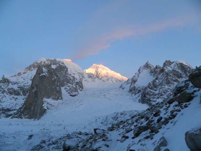
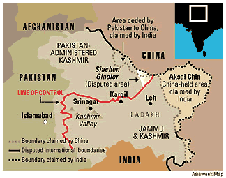
The Siachen Glacier is the longest glacier in the Karakoram Range of the Himalayas. It is also the world’s second most extended glacial range in the non-polar regions of the globe. Lying at geographical coordinates 35.46o N, 77.04o E, and at an altitude more than 5000m above sea level, the entire glacier is home to numerous significant passes guarded by the Indian Army. Covering 700 km2, Siachen receives an average winter snowfall of 1000cm dropping temperatures to -50oC. Map coordinate NJ 9842 lies at the foot of Siachen terminating the Line of Control (LoC) between India and Pakistan.
Background and Importance:
A resource-less and inhabitable—Siachen was never considered to have any significant values. However, with time, the glacier has become a region of much military importance. For over three and a half decades now, both India and Pakistan have been in a standstill war over the territorial claim of Siachen.
When India and Pakistan separated from each other and gained independence, princely state Jammu and Kashmir remained independent under the rule of Maharaja Hari Singh. Weeks later, Pakistan sent tribal militia to capture Kashmir. The Maharaja hoped to seek military assistance from India. However, the Indian Government did not provide any service. Instead, informed the Maharaja that only if he acceded Jammu and Kashmir to the Dominion of India, the Indian army would battle against the Pakistani invaders. With no other resort, Maharaja Hari Singh agreed and signed the treaty Instrument of Accession acceding to India. The Indian army instantly set forth to Srinagar to push the Pakistani forces back into their territory. The war between the two newly formed countries continued for more than thirteen months. Without any consultation with the Cabinet ministers, then-Indian Prime Minister, Jawaharlal Nehru reached out to the United Nations to sort the issue at hand. Without further ado, the UN commanded cease-fire as on date. The fronts of the battle solidified and were termed Line of Control (LoC) under military supervision. Till date, the result of the war remains inconclusive. A part of Kashmir belongs to Pakistan, also known as Pakistan occupied Kashmir (POK) or Azad Kashmir.
Furthermore, following the Indo-Pakistani War of 1971, the Simla Agreement of 1972 was signed. Demarcations of the territorial boundary between India and Pakistan were laid down. East of the Line of Control belonged to India, while the west belonged to Pakistan. The LoC terminated at map coordinate NJ 9842 and stated that the “Line of Control runs north-eastwards to Thang (inclusive of India), thence eastwards joining the glaciers.”
Thus, the Siachen glacier demarcates the international boundary of India and separates itself from Pakistan and China, which lie on either side of the triangular area.
By the 1970s, many foreign mountaineers began trekking into the Siachen Glaciers en route Pakistan. The vague and ambiguous territorial definition erupted further chaos and thirst for the extension of their own boundaries. Witnessing several groups of mountaineers survive the harsh climatic conditions of the glaciers posed a threat to both India and Pakistan for the other’s claim over the region. If mountaineers could survive the severe conditions, so would the army.
Using cartographic maps, it was found that:
- On the west of Siachen lies Saltoro Ridge (part of Pakistan), which provides a direct link via Pakistan occupied Kashmir (POK) to China on the east of the glacier. Owing to its height, Siachen would act as a watchtower for India to keep a keen eye on Gilgit and Baltistan areas of Pakistan to prevent any military disturbances.
- However, if Pakistan gets control over Siachen, they are bound to pose a significant threat to India from the west via Ladakh. Similarly, threats from China on the east via Aksai Chin are highly expectable.
The Conflict:
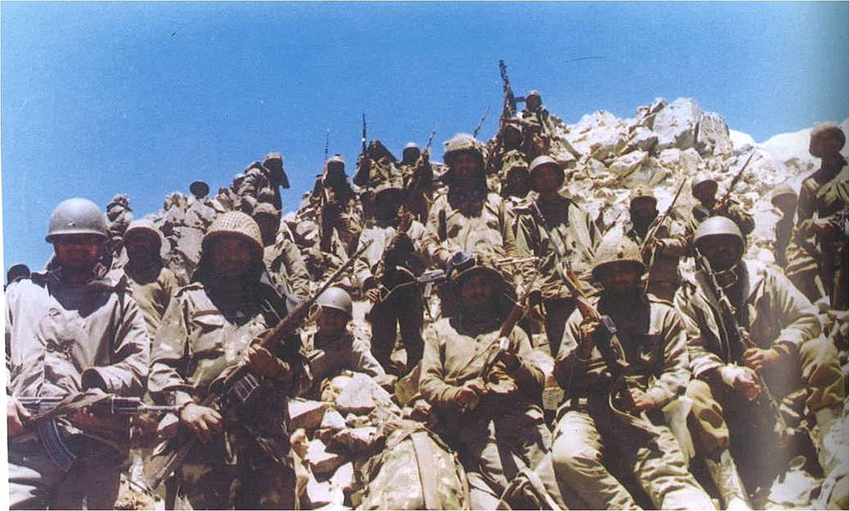
As a pro-active move, India’s Northern Command, Indian Lieutenant General Manohar Lal Chibber, had sent out an army reconnaissance into Siachen as early as 1978 to observe the conditions in the glaciers. After the expedition troop returned, it was decided that regular patrolling would be done from vantage points of the glaciers for better views on the highways below. Moreover, it was concluded that patrolling would be done only during summers as winters were severe. Therefore it ruled out the establishment of permanent posts.
In September-October 1983, Indian intelligence discovered Pakistani troops moving into Siachen with motives of occupying vantage points. The operation was termed “Operation Ababeel.” However, due to the harsh climate, they withdrew from their mission. To date, many Pakistanis continue to argue that “no evidence exists that Pakistan had ever contemplated establishing a military post in Siachen.” Thus, began the world’s coldest trench war on the highest battlefield in endless sheets of ice, amid avalanches and unavoidable deaths.
Operation Meghdoot 1984
On April 13, 1984, two months ahead of regular mountaineering season, India flung into action and began their way up Siachen under the code name “Operation Meghdoot.” The operation was only a pre-emptive act to gain control over the glaciers. Much to the surprise of the Indian Army, news about “Operation Meghdoot” circulated town and obviously into Pakistan as well.
As a breach of the Simla Agreement 1972, Pakistan immediately backfired by sending its army into Siachen. Indian and Pakistani troops continued to find their way to peak positions.
Till this date, the Indian Army patrols the higher peaks of the glacier while the lower altitudes are guarded by the Pakistani Army. This standstill war is permanent, with neither army willing to back down.
Battle for life
Any soldier marching their way up Siachen fears the consequences of his health. The oxygen levels in the dense glaciers of Siachen are less than ten per cent, making a soldier’s body weak and sluggish and therefore causing a lack of appetite. Col. Kohli said, “If you are sitting outside on a nice sunny day with not a cloud in sight, you can get a sunburn and frostbite at the same time.” He added, “If you touch a weapon even briefly without gloves on, you could lose a part of your skin or even the hand. Such cases are common.” Without goggles, the glare of the white could blind a soldier.
Avalanches in the mountains are frequent. However, surviving those avalanches is a challenge. Until the year 2000, soldiers used to live in snow tents, which were ripped apart and blown away by the snowstorms. Now fibreglass huts have replaced the tents. The huts have a window primarily used to allow sun rays into the hut though it is also used as an emergency exit during the storms. About six people are accommodated in every fibreglass panel. Usually, two panels are joined, allowing twelve people to live together. There are struggles with the hut as well. Every few weeks, the anchoring of the hut weakens, thereby loosening the structure. New patches are dug up and levelled, securing the structure.
Breathlessness, headaches, loss of orientation, nose bleeds, stomach ulcers, skin, and respiratory problems are regular difficulties in the high altitudes. There have been many incidents of soldiers dying in their sleep due to carbon monoxide poisoning produced by ‘buhkaris,’ which are meant to keep the fibreglass panels warm. Further, dehydration, high-altitude pulmonary oedema, and high-altitude cerebral oedema are worst feared as they may be fatal.
At heights above 5000m, soldiers rely on helicopters. Supplies, including food, are dropped from helicopters between 5 am and 7 am at sunrise. As temperature during the day increases, the pressure in the air decreases, affecting the flight of the chopper. Retired colonel, Kohli mentioned that helicopter rotors are never switched off in Siachen because it may not start again.
Kargil War 1999
In May 1999, Pakistani troops infiltered into the Indian boundary of the LoC to occupy Ladakh from the Northern Areas of the state, which belong to Pakistan. The plan was to disconnect the link between Kashmir and Ladakh, causing the Indian Army to withdraw from Siachen. Local army commanders did not take the intrusions seriously, assuming they were minor infiltrations by routine terrorists. Meanwhile, 4 to 6 Pakistani battalions of their Northern Light infantry intruded into carefully strategised positions. The vantage posts directly overlooked National Highway 1-A, the prime highway connecting Srinagar and Leh. This highway is one of the only two routes connecting Ladakh to the rest of India. Getting accurate access to the National Highway, Pakistanis began artillery firing stalling all traffic plying on it.
Consternated over the firing, India immediately reacted with immense firepower, including air force jets, artillery guns, and multiple rocket launchers. After three months of battle, India was announced victor of the war. During the war, nearly 490 Indian officers, soldiers, and jawans sacrificed their lives fighting for the nation. Around 400 Pakistanis were said to have lost their lives. To commemorate India’s triumph, every year, July 26 is celebrated as Kargil Vijay Diwas.
Cost of handling Siachen
Over 10000 troops from India have been deployed to Siachen. Supplies of food and armaments traverse through long, narrow, and rather tricky distances to reach the army men. Following either the Manali-Baralacha La-Leh road or Jammu-Banihal-Srinagar-ZojiLa-Kargil-Leh routes, convoys travel in the summer months from April to early November only. To reach Siachen, though, trucks must travel through the world’s highest motorable pass—Khardung La, which at the height of 18,380 feet and then around 200km to Siachen base camp. Over the years, the soldiers have found their ways for better storage processes of provision and equipment. Approximately 1,80,000 tonnes of conditions are required annually in Ladakh.
In April 1998, Defence Minister George Fernandes from National Democratic Alliance (NDA) government paid a visit to Siachen to understand the living conditions of the country’s army men. This was the first time any official from the Ministry set foot on the glaciers. Understanding that bureaucrats had ignored the requests of the Indian Army to supply snowmobiles for commuting in the glaciers for three years, Fernandes took immediate action. He sent two bureaucrats to Siachen to witness first-hand the difficulties of the country’s soldiers. Since then, the government has provided ten snowmobiles to Siachen every year. During his period as Defence Minister, Fernandes visited Siachen 32 times earning the title “Siachen Minister.”

India spends about Rs. 5 crores a day for the soldiers living in the inhabitable terrains. The Indian Government has spent a total of about Rs 7500 crore for clothing and mountaineering equipment since 1984.
In 2010, the Indian Government began the construction of a 9.02 km highway tunnel—Atal Tunnel (formerly known as Rohtang Tunnel) along the Leh-Manali Highway. The tunnel is one of the longest tunnels in the country and is expected to reduce the commuting distance between Leh and Manali by 46 km. Built at an elevation of 3,100 m Atal tunnel is an all-season, all-weather route, which strategically connects essential parts of Ladakh. It is therefore an easier route to Siachen. The tunnel is named after former Prime Minister Atal Bihari Vajpayee who took the initiative of constructing this road network. The tunnel is set for inauguration on October 3, 2020.
Some sources report around 900 deaths of Indian soldiers in Siachen since 1984 due to climatic conditions, avalanches, frostbites, and other environmental factors.
Importance of the Indian Army based in Siachen
Many officers believe that the demilitarisation of Siachen should take place. However, for India stepping down from Siachen means losing Jammu and Kashmir and uniting both of India’s enemies.
- The Saltoro Ridge is guarded by the Pakistani army. They stand about 3000 feet below nearly 50 Indian posts. In case Pakistan strikes any territorial disputes, India is better positioned due to the height at which they are stationed.
- Given the strategic alliance of China and Pakistan, Pakistan had ceded around 2000 km2 of territory in the Shaksgam region to China. Over the years, China has developed all-weather road and rail links in the area. Siachen helps India keep a close watch on China’s infrastructural activities.
- If India ceded the Indian-controlled Karakoram Pass triangle to Pakistan, it would have further strengthened Sino-Pak relations threatening India.
Indian and Pakistani army have permanently stationed themselves in Siachen. Neither is willing to retire from their position. Though some may say the Siachen Conflict ended on November 25, 2003, the battle for the territory continues. As Stephen P. Cohen, an authority on the Indian Constitution at Brookings Institution, described, “Siachen is the epitome of the worst aspects of the relationship. It is like two bald men fighting over a comb.” Siachen prolongs to be the world’s highest, coldest, costliest, and wasteful battles.
Written by Vaishnavi Karkare for MTTN
Featured Image by Sara Dharmik for MTTN
Sources: Economic Times; Bharat Rakshak; Perception, Politics and South Asia; News Warrior
Image Sources: Glacier Hub, Asia Now, Wikipedia, DNA India